

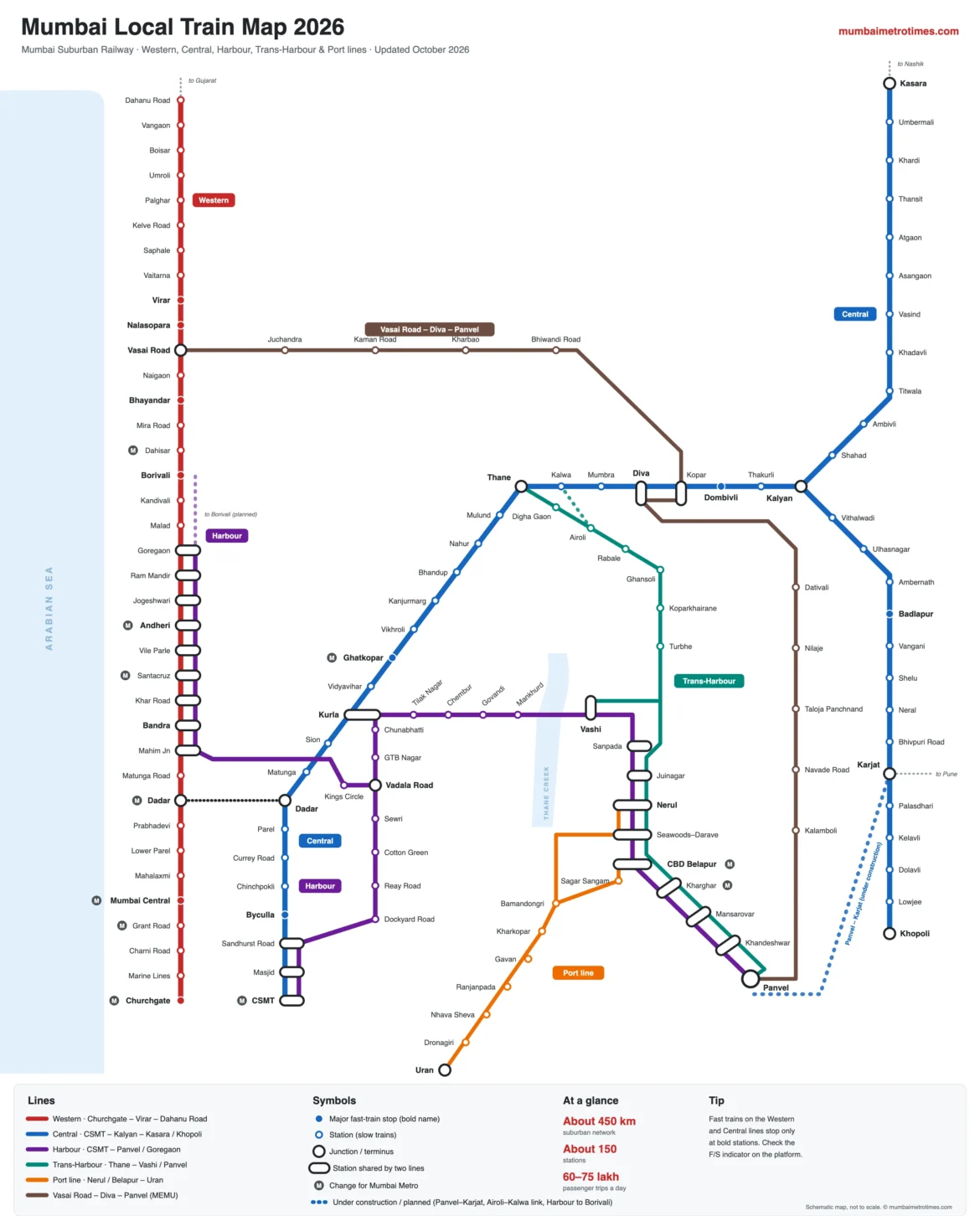
Looking for a clear Mumbai local train map (also called the Mumbai local map or Mumbai railway map)? This page has an up-to-date map of the whole Mumbai Suburban Railway — the Western, Central, Harbour and Trans-Harbour lines, the Port line to Uran and the Vasai Road – Diva – Panvel line — with every station, the major fast-train stops, junctions and Mumbai Metro interchanges. Below the map you will find a route map and station list for each line — Western, Central, Harbour and Trans-Harbour — a list of interchange stations and tips on reading the map. For tickets, fares, rules and timings, see our full Mumbai local train guide.
Updated October 2026 · All suburban lines and stations
Lines
5 corridors + Vasai – Diva – Panvel
Stations
About 150
Network
About 450 km
Daily trips
About 60–75 lakh
Schematic map, not to scale. Station names follow the station boards; check the RailOne app or station displays for train times.
Mumbai local train map 2026
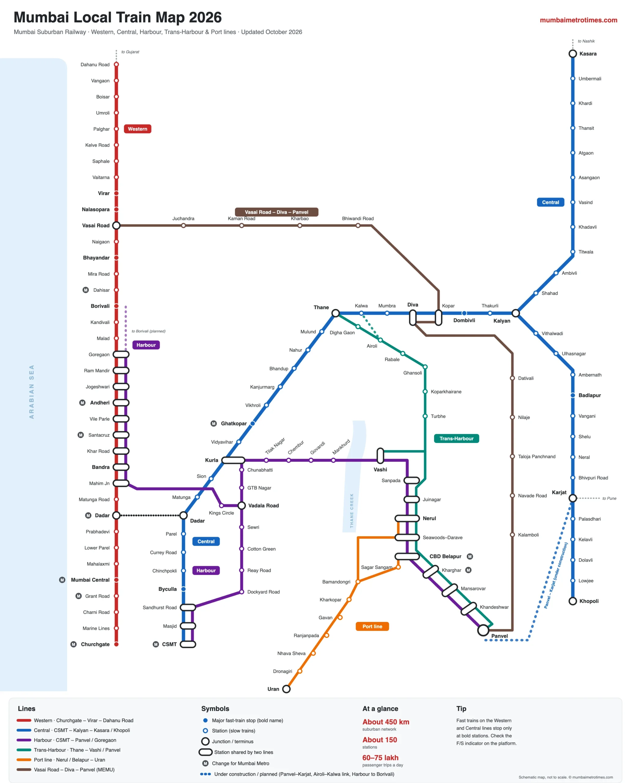
Tap the map to open the full-size version. On a phone, pinch to zoom, or save the image to use it offline. Bigger filled dots and bold names show major fast-train stops; white pill shapes are stations shared by two lines.
How to read the Mumbai local train map
The map draws each line in a different colour so it is easy to follow, and the same colours are used on the route maps further down this page. These colours are only for this map — Mumbai local train lines do not have official colour names, unlike the Mumbai Metro, whose lines are called the Red Line, Blue Line, Yellow Line, Aqua Line and so on. Locally, the lines are known simply by their names:
- Western line: Churchgate to Virar and Dahanu Road, run by Western Railway.
- Central line: CSMT to Kalyan, then to Kasara or Khopoli, run by Central Railway.
- Harbour line: CSMT to Panvel, and CSMT to Goregaon via Bandra and Andheri.
- Trans-Harbour line: Thane to Vashi, Nerul and Panvel through Navi Mumbai.
- Port line (Uran line): Nerul and CBD Belapur to Uran.
- Vasai Road – Diva – Panvel line: an outer connector line with MEMU passenger trains.
- Filled dot and bold name: a major fast-train stop on the Western or Central line. Fast trains do not stop at the other stations.
- White dot: a station served by slow trains (on the Harbour, Trans-Harbour and Port lines, every train stops at every station).
- Black ring: a junction or terminus, such as Dadar, Kurla, Thane, Kalyan or Panvel.
- White pill: a station shared by two lines, where you can change trains — for example Bandra and Andheri (Western and Harbour) or Nerul (Harbour, Trans-Harbour and Port).
- Grey “M” badge: you can change here for the Mumbai Metro.
- Dashed line: a line under construction or planned, such as Panvel – Karjat.
Mumbai local train lines at a glance
| Line | Route | Operator | Main junctions |
|---|---|---|---|
| Western line | Churchgate – Mumbai Central – Dadar – Andheri – Borivali – Virar – Dahanu Road | Western Railway | Dadar, Bandra, Andheri, Vasai Road |
| Central line | CSMT – Dadar – Kurla – Thane – Kalyan – Kasara / Khopoli | Central Railway | Dadar, Kurla, Thane, Diva, Kalyan, Karjat |
| Harbour line | CSMT – Vadala Road – Kurla – Vashi – Panvel; Vadala Road – Bandra – Andheri – Goregaon | Central Railway | Vadala Road, Kurla, Vashi, Nerul, Panvel |
| Trans-Harbour line | Thane – Airoli – Turbhe – Vashi / Nerul – Panvel | Central Railway | Thane, Sanpada, Juinagar, Nerul, Panvel |
| Port line | Nerul / CBD Belapur – Bamandongri – Kharkopar – Uran | Central Railway | Nerul, CBD Belapur |
| Vasai Road – Diva – Panvel | Vasai Road – Bhiwandi Road – Kopar – Diva – Panvel | Central & Western | Vasai Road, Kopar, Diva, Panvel |
The Western and Central lines are the two long trunk routes, each well over 100 km. The Harbour and Trans-Harbour lines carry passengers into Navi Mumbai, and the Port line serves Uran and the JNPA port area. For more on each line, including AC locals and how trains run, read the Mumbai local train guide.
Mumbai local train route map and station list for each line
Tap a line to open its route map. Together, these make up a complete Mumbai local train station list, with every station in order from one end of the line to the other. Bigger filled dots mark major fast-train stops; on a phone, swipe each route sideways to see every station.
Western line map · Churchgate – Virar – Dahanu Road
Major fast-train stop Slow trains only Swipe to see all stations →
- Churchgate
- Marine Lines
- Charni Road
- Grant Road
- Mumbai Central
- Mahalaxmi
- Lower Parel
- Prabhadevi
- Dadar
- Matunga Road
- Mahim Jn
- Bandra
- Khar Road
- Santacruz
- Vile Parle
- Andheri
- Jogeshwari
- Ram Mandir
- Goregaon
- Malad
- Kandivali
- Borivali
- Dahisar
- Mira Road
- Bhayandar
- Naigaon
- Vasai Road
- Nalasopara
- Virar
Beyond Virar
- Virar
- Vaitarna
- Saphale
- Kelve Road
- Palghar
- Umroli
- Boisar
- Vangaon
- Dahanu Road
Central line map · CSMT – Kalyan – Kasara / Khopoli
Major fast-train stop Slow trains only Swipe to see all stations →
- CSMT
- Masjid
- Sandhurst Road
- Byculla
- Chinchpokli
- Currey Road
- Parel
- Dadar
- Matunga
- Sion
- Kurla
- Vidyavihar
- Ghatkopar
- Vikhroli
- Kanjurmarg
- Bhandup
- Nahur
- Mulund
- Thane
- Kalwa
- Mumbra
- Diva
- Kopar
- Dombivli
- Thakurli
- Kalyan
Kasara branch
- Kalyan
- Shahad
- Ambivli
- Titwala
- Khadavli
- Vasind
- Asangaon
- Atgaon
- Thansit
- Khardi
- Umbermali
- Kasara
Karjat / Khopoli branch
- Kalyan
- Vithalwadi
- Ulhasnagar
- Ambernath
- Badlapur
- Vangani
- Shelu
- Neral
- Bhivpuri Road
- Karjat
- Palasdhari
- Kelavli
- Dolavli
- Lowjee
- Khopoli
Harbour line map · CSMT – Panvel / Goregaon
All trains stop at every station on this line Swipe to see all stations →
Common section
- CSMT
- Masjid
- Sandhurst Road
- Dockyard Road
- Reay Road
- Cotton Green
- Sewri
- Vadala Road
To Panvel
- Vadala Road
- GTB Nagar
- Chunabhatti
- Kurla
- Tilak Nagar
- Chembur
- Govandi
- Mankhurd
- Vashi
- Sanpada
- Juinagar
- Nerul
- Seawoods–Darave
- CBD Belapur
- Kharghar
- Mansarovar
- Khandeshwar
- Panvel
To Goregaon
- Vadala Road
- Kings Circle
- Mahim Jn
- Bandra
- Khar Road
- Santacruz
- Vile Parle
- Andheri
- Jogeshwari
- Ram Mandir
- Goregaon
Trans-Harbour line map · Thane – Vashi / Panvel
All trains stop at every station on this line Swipe to see all stations →
- Thane
- Digha Gaon
- Airoli
- Rabale
- Ghansoli
- Koparkhairane
- Turbhe
Vashi branch
- Turbhe
- Sanpada
- Vashi
Panvel branch (then Harbour line stations)
- Turbhe
- Juinagar
- Nerul
- Seawoods–Darave
- CBD Belapur
- Kharghar
- Mansarovar
- Khandeshwar
- Panvel
Uran (Port) line map · Nerul / Belapur – Uran
All trains stop at every station on this line Swipe to see all stations →
From Nerul
- Nerul
- Seawoods–Darave
- Bamandongri
- Kharkopar
From Belapur
- CBD Belapur
- Sagar Sangam
- Bamandongri
- Kharkopar
Kharkopar to Uran
- Kharkopar
- Gavan
- Ranjanpada
- Nhava Sheva
- Dronagiri
- Uran
Vasai Road – Diva – Panvel line map
All trains stop at every station on this line Swipe to see all stations →
- Vasai Road
- Juchandra
- Kaman Road
- Kharbao
- Bhiwandi Road
- Kopar
- Diva
- Dativali
- Nilaje
- Taloja Panchnand
- Navade Road
- Kalamboli
- Panvel
Junctions and interchange stations
These are the most useful places to change between lines. Changing at the right junction can save a lot of time, especially in the morning and evening rush.
| Station | Lines | Good for |
|---|---|---|
| Dadar | Western, Central | The busiest interchange; change between the two main lines |
| Kurla | Central, Harbour | Change for Chembur, Vashi and Panvel |
| Thane | Central, Trans-Harbour | Change for Airoli, Ghansoli, Vashi and Navi Mumbai |
| Bandra, Andheri | Western, Harbour | Harbour trains to Vadala Road and CSMT; Andheri also has Metro Line 1 |
| CSMT, Masjid, Sandhurst Road | Central, Harbour | Shared stations at the southern end; CSMT also has long-distance trains |
| Vadala Road | Harbour (both branches) | Change between the Panvel and Goregaon branches |
| Vashi, Sanpada, Juinagar, Nerul | Harbour, Trans-Harbour | Change between trains to CSMT and trains to Thane |
| Nerul, CBD Belapur | Harbour, Trans-Harbour, Port | Change for Uran |
| Panvel | Harbour, Trans-Harbour, Vasai – Diva – Panvel | Long-distance trains towards Goa and Konkan |
| Kalyan | Central (Kasara and Khopoli branches) | Change between the two branches; long-distance trains |
| Diva, Kopar, Vasai Road | Vasai – Diva – Panvel with Central / Western | Cross-suburb trips without going through the city |
| Karjat | Central (Khopoli branch) | Change for shuttles to Khopoli; trains towards Pune |
Local train and Mumbai Metro connections
Many local train stations now connect with the Mumbai Metro, shown with an “M” badge on the map. See the Mumbai Metro map for every metro line and station.
| Local train station | Metro line | Useful for |
|---|---|---|
| Andheri (Western, Harbour) | Line 1 Andheri | Saki Naka, Marol, Ghatkopar; change to Line 3 at Marol Naka |
| Ghatkopar (Central) | Line 1 Ghatkopar | Andheri and the western suburbs without going via Dadar |
| Churchgate, Grant Road, Mumbai Central (Western) | Line 3 | Cuffe Parade, Worli, BKC and the airport |
| CSMT, Dadar | Line 3 | Kalbadevi, Worli, Siddhivinayak, BKC |
| Santacruz (Western, Harbour) | Line 3 | BKC and the airport terminals |
| Dahisar (Western) | Line 2A / Line 7 | Andheri (E) and Andheri (W) along the highways |
| CBD Belapur, Kharghar (Harbour, Trans-Harbour) | Navi Mumbai Metro | Kharghar, Taloja and Pendhar |
Fast and slow trains
On the Western and Central lines, trains run as fast or slow. Fast trains use separate tracks and stop only at the bold stations on the map, such as Dadar, Bandra, Andheri, Borivali, Ghatkopar, Thane and Kalyan. Slow trains stop at every station. Platform indicators show F or S next to each train, together with its destination and the number of coaches (12 or 15).
Some trains also run semi-fast — fast for part of the journey and slow for the rest — so always check the stops shown on the indicator. Harbour, Trans-Harbour and Port line trains stop at every station.
Upcoming changes to the map
Several projects under the Mumbai Urban Transport Project (MUTP) will add new lines and tracks. They are shown as dashed lines on the map where they add a new route:
- Panvel – Karjat corridor: a new suburban line linking the Harbour line at Panvel with the Central line at Karjat, targeted for December 2026.
- Airoli – Kalwa elevated link: will let Trans-Harbour trains run towards Kalwa and Kalyan without entering Thane station; the first phase with Digha Gaon station opened on 12 January 2024.
- Harbour line to Borivali: a planned extension of the Harbour line from Goregaon to Borivali.
- More tracks: fifth and sixth lines between Borivali and Virar (targeted for 2029), quadrupling between Virar and Dahanu Road (2028), and third and fourth lines between Kalyan and Badlapur (2028).
- New trains: 238 new AC train sets have been approved, and non-AC locals with automatic doors are being trialled.
Tips for using the map
- Save the full-size map to your phone before you travel — mobile signal can be weak inside crowded trains and stations.
- Find your nearest junction first: most cross-city trips need one change at Dadar, Kurla, Thane, Andheri or Vashi.
- If your station is not a bold fast stop, board a slow train, or ride a fast train to the nearest bold station and change.
- For trips to Navi Mumbai from Thane, Kalyan or Dombivli, the Trans-Harbour line from Thane is usually faster than going via Kurla.
- Combine local trains with the metro to reach places away from the railway lines — for example Line 1 from Andheri or Ghatkopar.
- Buy your ticket or pass before boarding — on the RailOne app, at an ATVM or at the booking office. See the Mumbai local train guide for fares and passes.
Frequently asked questions
Where can I see the Mumbai local train map?
The map at the top of this page shows every Mumbai local train line and station — Western, Central, Harbour, Trans-Harbour, the Port line to Uran and the Vasai Road – Diva – Panvel line. Tap it to open the full-size version and save it to your phone so you can use it offline.
How many lines are there in the Mumbai local train network?
There are five main suburban corridors: the Western line, the Central main line, the Harbour line, the Trans-Harbour line and the Port line (Nerul / Belapur – Uran). The Vasai Road – Diva – Panvel line links them around the edge of the city and carries MEMU passenger trains.
What do the bold station names on the map mean?
Bold names with a filled dot are major fast-train stops on the Western and Central lines. Fast trains skip the other stations, so if your station is not in bold, take a slow train or change at the nearest fast stop.
Where can I change between the Western and Central lines?
The main interchange is Dadar, where the Western and Central stations stand side by side and are connected by foot-over-bridges. You can also travel via the Harbour line, which meets the Western line at Bandra and Andheri and the Central line at Kurla.
Which station connects the Central and Harbour lines?
Kurla is the main interchange between the Central and Harbour lines. CSMT, Masjid and Sandhurst Road are shared by both lines too, and Vadala Road is where the Harbour line splits towards Panvel and Goregaon.
Which local train stations connect with the Mumbai Metro?
Andheri and Ghatkopar connect with metro Line 1; Churchgate, Grant Road, Mumbai Central, Dadar, Santacruz and CSMT are close to metro Line 3; Dahisar is near Line 2A and Line 7; and CBD Belapur and Kharghar connect with Navi Mumbai Metro. See the Mumbai Metro map for all metro lines.
Is the Uran line shown on the Mumbai local train map?
Yes. The Port line runs from Nerul and CBD Belapur through Bamandongri and Kharkopar to Uran. Its final section from Kharkopar to Uran opened on 12 January 2024, so it is now fully operational.
Can I download the Mumbai local train map?
Yes. Tap the map to open the full-size image, then long-press (on a phone) or right-click (on a computer) and choose “Save image” to keep it for offline use. You are welcome to use it for personal travel.
Which new lines will be added to the Mumbai local train map?
The Panvel – Karjat line is close to completion, the Airoli – Kalwa elevated link is being built in phases, and the Harbour line is planned to extend from Goregaon to Borivali. Extra tracks between Borivali and Virar, Virar and Dahanu Road, and Kalyan and Badlapur will also allow more trains.
Is there a Mumbai local train map PDF?
The map on this page is a high-resolution image rather than a PDF, which makes it quicker to open on a phone. Tap it to open the full-size version and save it to your phone, or open it on a computer and use Print → Save as PDF if you prefer a PDF copy to print.
How many stations are there on the Mumbai local train network?
There are about 150 suburban stations across the Western, Central, Harbour, Trans-Harbour and Port lines. The Western line alone has about 37 stations between Churchgate and Dahanu Road, and the Central line runs from CSMT to Kasara and Khopoli.
Related: Mumbai local train guide · Mumbai Metro map · Navi Mumbai Metro
Sources: Wikipedia – Mumbai Suburban Railway · MUTP status report (Aug 2026) · Free Press Journal – RailOne (Feb 2026) · Daijiworld – automatic-door local (Apr 2026)